


The initial engagement with the MOLE deep-drilling vehicle can be an intimidating prospect, particularly when cryptic messages serve as the sole navigational aids. However, the fate of Earth rests upon the proficiency of its navigator, and this guide is designed to equip players with the essential knowledge to locate coordinates and chart a course through the subterranean unknown in the game MOLE.
The Critical Role of Navigation in the MOLE Simulation
The MOLE simulation places players in the crucial role of a deep-earth navigator, tasked with a mission of paramount importance: securing Earth’s future. This mission hinges on the precise operation of the MOLE, a sophisticated drilling apparatus designed to traverse the planet’s crust and access vital resources or data. The game’s core mechanics revolve around deciphering complex geological data, calculating precise drilling trajectories, and managing the vehicle’s operation under challenging subterranean conditions. Without a thorough understanding of the navigation systems and the interplay of various in-game tools, the mission’s success is jeopardized. The narrative framework suggests a scenario where conventional methods of resource acquisition or scientific exploration have proven insufficient, necessitating the deployment of this advanced drilling technology. The urgency implied by the "Earth depends on its navigator" tagline underscores the high stakes involved, hinting at potential existential threats that the MOLE is intended to address.
Unlocking the Secrets: Locating and Inputting Coordinates
The process of establishing a navigational bearing within the MOLE begins with the acquisition of precise coordinates. Players will encounter two primary methods for obtaining this critical data, with the second method typically becoming accessible on the second in-game day, signifying a progression in the simulation’s complexity.
The Primary Coordinate Acquisition Loop: Navigation Cassettes and Seismic Data
The foundational gameplay loop for obtaining coordinates relies on the strategic use of the Navigation Cassette. Upon entering the Cockpit, players will find a console positioned to their immediate left. This console is equipped with a small display screen, a lever, and an input slot for the cassette. The initial step involves inserting the Navigation Cassette into this terminal. Once secured, the lever must be pulled to initiate the upload of seismic data. This process is visually represented by an upload bar that gradually fills. Players must allow this bar to reach its full capacity, 100 percent, before carefully removing the cassette.
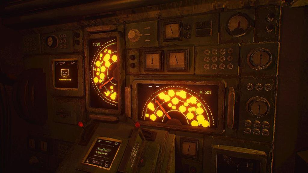
Following the seismic data upload, the player must engage with a separate computer terminal, typically located opposite the initial console. Interacting with this terminal and pressing the Spacebar initiates the decryption of the gathered seismic data. Once the data has been successfully decrypted, the Navigation Cassette must be re-inserted into the main console situated on the left wall. This console features two smaller levers. The player’s attention should be focused on aligning these levers with corresponding empty spaces displayed above them. The objective here is to navigate through virtual "rock clusters," using the levers to direct a straight path through these clear zones. Successful alignment will yield both the Y and X coordinates, which are essential for plotting the MOLE’s course. These numerical values are then inputted into the keypads located at the pilot’s seat, after activating the system by pulling a red handle. This methodical approach ensures that the MOLE is directed towards its intended subterranean destination with utmost accuracy.
Intermediate Coordinate Calculation: The Role of the Ground Density Chart
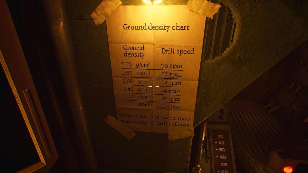
Once the initial coordinates have been entered and the MOLE is primed for subterranean traversal, the player must ascertain the optimal drilling speed. This is achieved by returning to the two small levers adjacent to the pilot’s seat, which now relate to the Terrain Density display. A crucial tool in this phase is the Ground Density Chart, located next to the pilot’s seat. This chart provides a conversion key, correlating geological density (measured in g/cm³) to the appropriate drill speed.
It is imperative to understand that the measured ground density may not always correspond precisely with a designated drill speed. In such instances, players must utilize the Ground Density Chart to make informed adjustments, selecting the speed that best approximates the geological conditions. This chart serves as a vital reference point and must be consulted each time a new set of coordinates is acquired and processed. The ability to accurately interpret and apply this data directly impacts the MOLE’s efficiency and its ability to navigate through varying subterranean strata without sustaining damage or encountering significant delays. The game’s design emphasizes a cyclical process of data acquisition, interpretation, and application, mirroring the complexities of real-world engineering and exploration.
Piloting the Drill: Engaging the Navigation Controls
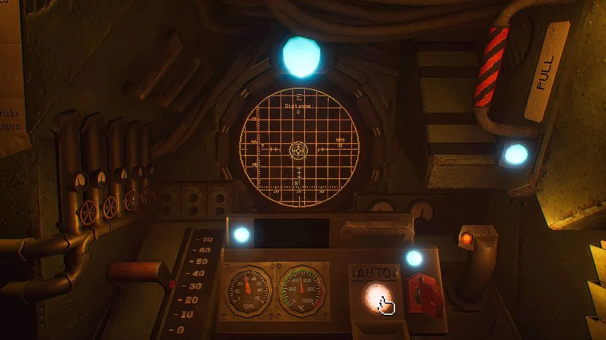
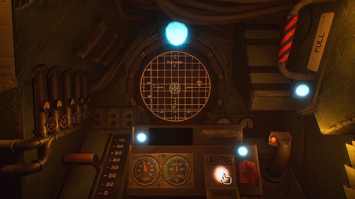
With the coordinates inputted and the drilling speed calibrated, the player can now assume direct control of the MOLE. Returning to the pilot’s seat, the calibrated speed is set using the red lever situated on the left. The primary control for directional movement is the navigation stick, located on the right. The player’s objective is to guide the MOLE, following a visible arrow displayed on a grid ahead. This guidance system visualizes the intended path, and the player must skillfully maneuver the MOLE until the piloting circle aligns perfectly with the stationary circle, which represents the target destination.
Upon achieving precise alignment, a crucial function becomes available: the ability to switch to "Auto" mode. This is activated by pressing a designated button, which appears only when the piloting circle and the destination circle are perfectly synchronized. Engaging Auto mode allows the MOLE to proceed autonomously to the target coordinates, freeing the player to monitor other critical systems or prepare for the next phase of the mission. The transition to Auto mode signifies a successful navigation sequence and a testament to the player’s ability to master the MOLE’s piloting mechanics. This phase of the gameplay highlights the importance of precision control and the strategic decision-making involved in managing the vehicle’s movement.
Advanced Navigation: Harnessing the Power of Cassettes
The MOLE simulation introduces advanced navigational tools that expand the player’s capabilities and introduce new layers of complexity. Beyond the initial Navigation Cassette, a second, specialized cassette plays a pivotal role in later stages of the game.
The Targeting Cassette and the White Rabbit Signal
The Targeting Cassette emerges as a critical component of advanced piloting, particularly after the in-game Lab becomes accessible on the second day. This cassette is instrumental in gathering new data related to a mysterious "Signal." To initiate its function, players must retrieve a crystal from the Geologist’s workstation. This crystal is then placed on a motherboard located beneath a monitor that prominently displays the "White Rabbit Signal."
The process of utilizing the Targeting Cassette involves a series of deliberate actions. First, the player must temporarily turn off the lights in the area. Once the lights are extinguished, the player interacts with the Signal itself. This interaction involves "staring" at the Signal until a visual cue, described as beams of light encircling a portion of the player’s vision, indicates that the system is actively acquiring data. Following this, the player must interact with the wall located behind them, still in the darkness. This interaction reveals a grid, on which the player must identify and record the radio frequency associated with the Signal.
After noting the frequency, the lights are switched back on. The Targeting Cassette is then inserted into the radio unit. The radio is equipped with two knobs for tuning. The top knob is used to set the first two digits of the recorded radio frequency, while the bottom knob is adjusted to input the remaining three digits. Finally, a small lever, distinguished by a red light beneath it, is pulled to "tune" the cassette to the specific frequency. This entire process is designed to extract and process specialized data that contributes to a more sophisticated understanding of the subterranean environment or the overarching objectives of the mission.
Integrating Targeting Data into Navigation
Once the Targeting Cassette has been tuned and its data processed, the player must return to the Cockpit. Here, the computer terminal becomes the interface for converting this specialized data into usable coordinates. This conversion process involves selecting three ".xyx" files, indicated by the game interface. The player selects these files by pressing the Spacebar for each. Once all three files have been selected, pressing Enter twice finalizes the conversion.
With these new, refined coordinates obtained, the player can then revert to the standard piloting procedure. This involves utilizing the Navigation Cassette as previously described, following the established method of uploading seismic data, decrypting it, and then piloting the drill to the newly acquired coordinates. The introduction of the Targeting Cassette signifies an evolution in the game’s complexity, requiring players to master new interfaces and integrate diverse data streams to achieve their objectives. This multi-stage data processing and integration mechanic underscores the game’s commitment to simulating a challenging and multifaceted operational environment.
Broader Implications and Future Considerations
The successful navigation and operation of the MOLE within the game simulation carry significant implications. On a narrative level, it suggests a world facing a critical challenge, where the very survival of Earth hinges on the success of this deep-drilling operation. The cryptic nature of the initial messages and the phased introduction of new technologies point towards a carefully orchestrated narrative that unfolds as the player progresses.
From a gameplay design perspective, the mechanics of coordinate acquisition, speed calibration, and piloting represent a sophisticated approach to simulation gaming. The integration of visual aids, data charts, and interactive terminals creates an immersive experience that demands both logical deduction and precise execution. The introduction of different cassette types and the progression of accessible features over in-game days ensures a sustained level of engagement and a gradual learning curve.
The analysis of terrain density and the conversion of raw data into actionable navigational information highlight the game’s commitment to simulating realistic operational challenges. The potential for failure, either through incorrect coordinate input, improper speed calibration, or imprecise piloting, adds a layer of tension and consequence to each mission.
Looking ahead, the game’s framework suggests further advancements and challenges that will likely require even more sophisticated navigation and resource management. The mystery surrounding the "White Rabbit Signal" and the ultimate purpose of the MOLE’s mission remain central to the unfolding narrative, promising a compelling journey into the unknown depths. The success of players in mastering these navigational intricacies will not only determine their individual progress within the game but also, in the context of the simulation, contribute to the preservation of Earth. The game’s design encourages a methodical and analytical approach, rewarding players who can effectively interpret complex data and execute precise maneuvers under pressure. This emphasis on skilled operation and intelligent decision-making positions MOLE as a noteworthy entry in the simulation and strategy genre, offering a unique and engaging challenge for players.