


The initial moments of piloting the MOLE can be a disorienting experience, marked by a stark absence of explicit instructions and the presence of enigmatic messages. Yet, the fate of Earth hinges on the proficiency of its navigator, placing a critical burden on the player to master the intricate mechanics of this subterranean exploration vessel. This guide delves into the essential procedures for acquiring coordinates and plotting a course within the challenging environment of MOLE, offering a detailed breakdown of gameplay mechanics and their strategic importance.
The Crucial First Steps: Acquiring Navigational Coordinates
The journey within MOLE necessitates the precise determination of coordinates, a process that unfolds in distinct phases. Initially, players rely on a singular, fundamental method to gather the vital directional data. This primary gameplay loop revolves around the Navigation Cassette, an indispensable tool for extracting seismic information.
Upon entering the Cockpit, players will immediately notice a terminal situated to their left. This console, characterized by a small display screen, a lever, and a slot for cassette insertion, serves as the gateway to understanding the subterranean landscape. The procedure begins by inserting the Navigation Cassette into this terminal. Once the cassette is in place, the lever must be actuated. This action initiates the upload of seismic data, visually represented by a progress bar that ascends to 100 percent. It is imperative to remove the cassette only after this upload is complete, ensuring the integrity of the collected data.
Following the seismic data acquisition, the player must then engage with a secondary computer terminal, positioned directly opposite the cassette insertion point. Interacting with this terminal and pressing the Spacebar initiates the decryption process, transforming raw seismic readings into usable navigational information.
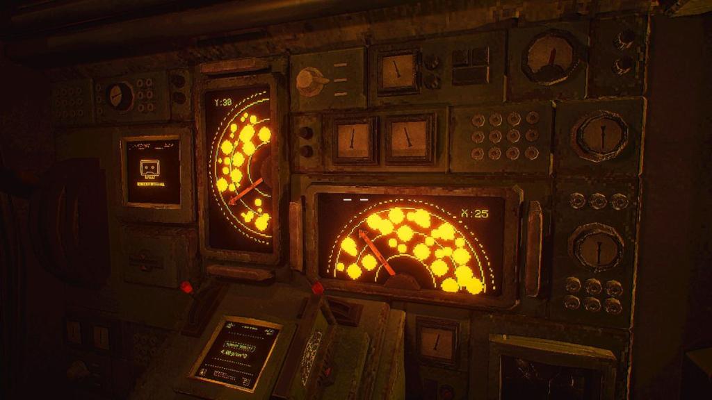
The decrypted data is then transferred back to the main console, located on the left wall of the Cockpit. This console features two smaller levers. The primary objective here is to meticulously set these levers to align with the empty spaces displayed above them. This alignment process is not arbitrary; it requires careful observation to avoid areas marked as rock clusters. The goal is to guide a directional arrow through these clear passages, thereby pinpointing the Y and X coordinates. Once both sets of numerical coordinates are successfully identified, they must be inputted into the keypads situated at the pilot’s seat. This action is typically preceded by pulling a red handle, signaling readiness for data entry.
Mastering the Subterranean Drill: Speed, Density, and Navigation
With coordinates firmly established, the next critical phase involves calibrating the MOLE’s drilling apparatus and setting a course through the treacherous underground. The optimal speed for the drill is derived from the Terrain Density display, accessible via the same console where the two small levers are located.
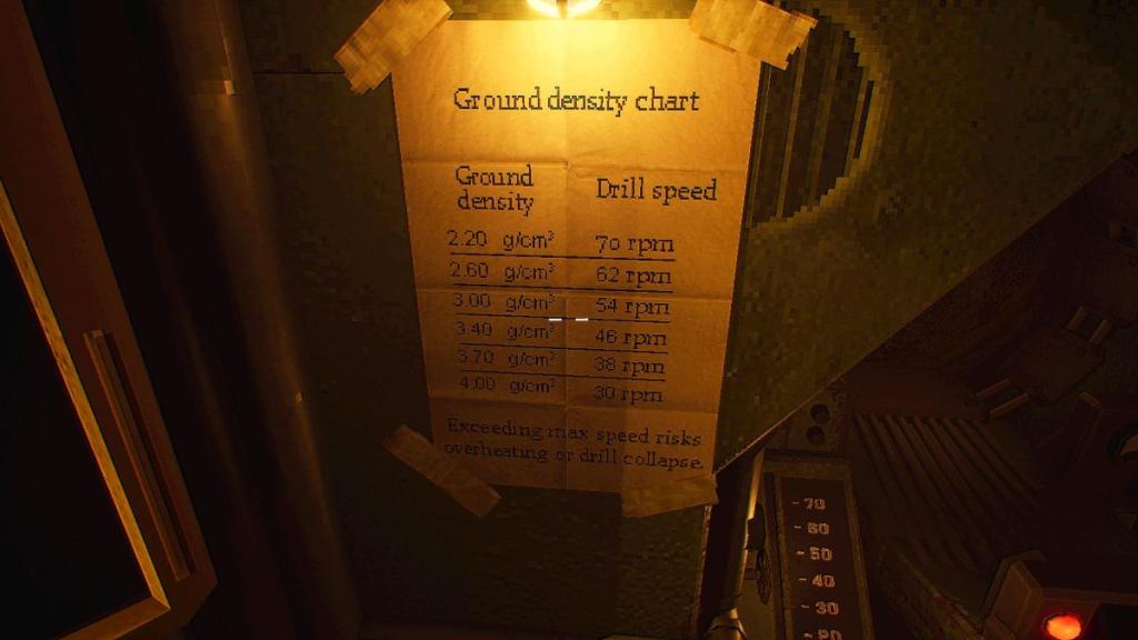
To determine the appropriate speed, players must consult the Ground Density chart, a crucial reference located next to the pilot’s seat. This chart provides a conversion key between grams per cubic centimeter (g/cm³) and the drill’s operational speed. It is important to note that the terrain density may not always correspond precisely to a pre-defined drill speed. In such instances, players must exercise judgment, adjusting the speed based on the guidelines presented in the chart. This chart should be referenced consistently with each new set of coordinates obtained, as subterranean conditions can vary significantly.
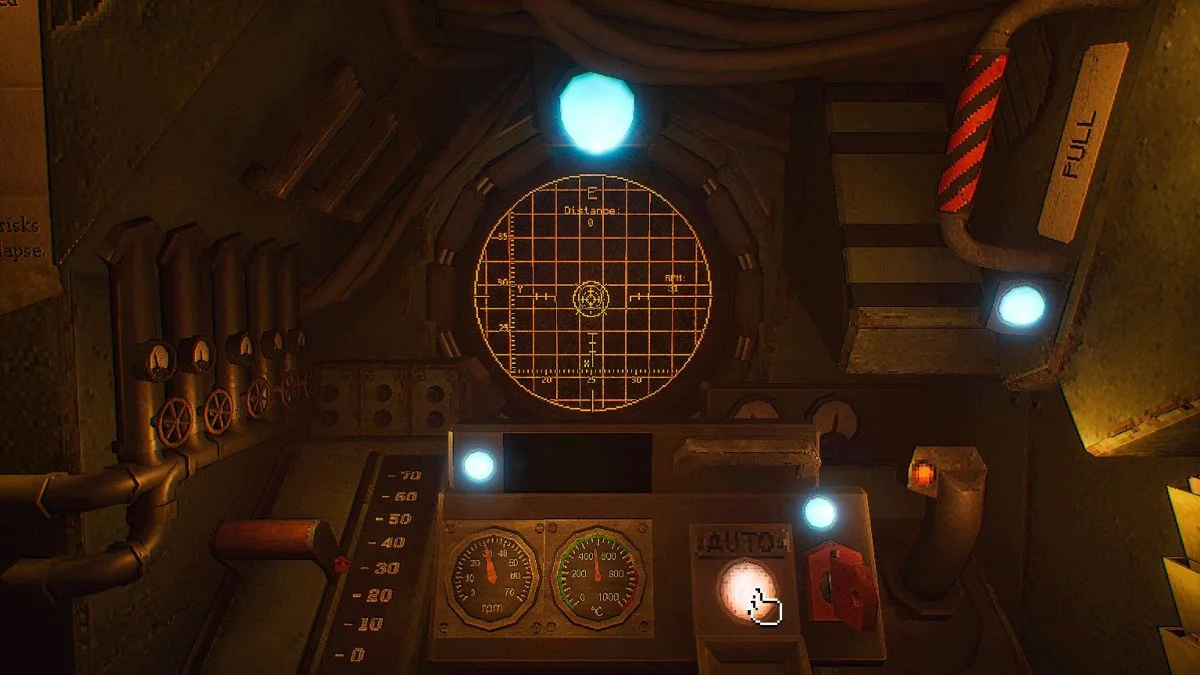
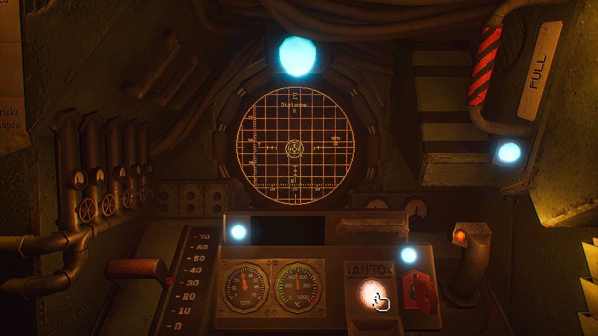
Once the speed has been calibrated, the player returns to the pilot’s seat, ready to commence the descent. The speed is adjusted using the red lever positioned on the left. The actual piloting of the drill is managed by the navigation stick on the right. The objective is to follow a directional arrow displayed on a grid ahead, guiding the drill until a piloting circle aligns perfectly with a stationary circle, which represents the destination. Upon successful alignment, a button will become available to switch the drill to Auto mode, a crucial step for maintaining a stable and efficient trajectory.
The Role of Cassettes in Plotting a Course: Beyond Navigation
While the Navigation Cassette is central to obtaining initial coordinates, its utility extends to a broader system of course plotting, especially as the game progresses. A second type of cassette, the Targeting Cassette, becomes instrumental in unlocking more advanced navigational capabilities, particularly after the Lab facility becomes accessible on the second day of gameplay.
The Targeting Cassette is integrated into the piloting process by first acquiring a crystal from the Geologist’s workstation. This crystal is then placed on a motherboard situated beneath a monitor displaying the White Rabbit Signal. This initiates a process that gathers new data related to the Signal.
To effectively utilize the Targeting Cassette, players must interact with the Signal while the lights in the Lab are turned off. This interaction involves focusing on the Signal until beams of light begin to encircle the player’s vision. Subsequently, with the lights still extinguished, players must interact with a grid located on the wall behind them. This interaction reveals a radio frequency, a critical piece of information for calibrating the Targeting Cassette.
Upon switching the lights back on, the Targeting Cassette is inserted into a radio apparatus. The calibration involves adjusting two knobs: the top knob is set to the first two digits of the radio frequency, and the bottom knob is adjusted to the subsequent three digits. A small lever, distinguished by a red light beneath it, is then pulled to tune the cassette to the precise frequency.
This newly acquired frequency data is then brought back to the Cockpit. Using the computer terminal, players convert this radio frequency information into a new set of coordinates. This conversion process typically involves selecting three .xyx files, indicated by pressing the Spacebar for each selection, followed by pressing Enter twice once all three files have been chosen. With these new coordinates derived from the Targeting Cassette, players can then revert to the familiar process of using the Navigation Cassette, following the established method to pilot the drill to the newly identified destination.
Contextualizing the Mission: Earth’s Survival and the MOLE Initiative
The overarching narrative of MOLE places the player in a desperate struggle for humanity’s survival. Earth, ravaged by an unspecified cataclysm, has rendered the surface uninhabitable, forcing the remaining population to seek refuge and resources deep within the planet’s crust. The MOLE, a sophisticated drilling and exploration vessel, represents the last hope for discovering new habitable zones, essential resources, and potentially, a path to rebuilding civilization.
The cryptic messages and the reliance on deciphering data are not merely gameplay mechanics but thematic elements that underscore the desperate and improvised nature of this survival effort. Information is scarce, and every piece of data, every successful navigation, is a small victory against overwhelming odds. The timeline of the game, indicated by the progression from day one to day two with the unlocking of new facilities like the Lab, suggests a structured, albeit challenging, campaign of exploration and resource acquisition.
Implications of Advanced Navigation Techniques
The introduction of the Targeting Cassette and its associated mechanics signifies a critical evolution in the player’s capabilities. Initially, navigation is a brute-force approach of seismic data interpretation. However, the ability to tap into radio frequencies and process them into coordinates suggests the presence of more advanced, possibly alien or forgotten, technologies within the subterranean environment. This could imply that the MOLE is not just a drill but a tool for uncovering deeper secrets of the planet and its history.
The "White Rabbit Signal" itself is an intriguing element, hinting at a narrative beyond mere survival. Its connection to the Targeting Cassette suggests it may be a beacon, a communication, or a key to unlocking further mysteries. The implication is that the MOLE’s mission is not solely about resource extraction but also about unraveling the enigma of Earth’s past and potentially, its future.
The success of these navigational endeavors has direct implications for the broader survival of the human colony. Each successfully charted course, each new resource discovered, directly contributes to the sustainability and potential expansion of the subterranean settlements. Conversely, navigational failures, incorrect speed calibrations, or misinterpretations of data could lead to catastrophic outcomes, including the destruction of the MOLE, the loss of vital resources, or the inability to locate safe havens. Therefore, mastering these intricate piloting and navigation systems is not just a matter of progressing through a game; it is a matter of life and death for the future of humanity. The constant need to adapt to varying terrain densities and interpret complex data streams emphasizes the unforgiving nature of this subterranean frontier and the critical importance of precise execution in every maneuver.